Showing posts with label maps. Show all posts

Monday, December 5, 2022

Real History: Rise and Fall of the Sea around Sundaland and Sahul

This animated map shows the rise and fall of sea levels around Sundaland over the centuries. From 04:30 it shows human migration paths.

This animated map shows the rise and fall of sea levels around Sahul, the area of what is now known as Australia and Papua New Guinea. It also shows the human migration paths from around the 4 minute mark.

Wednesday, September 16, 2020

21,000 Years in Sundaland

 Watch Sundaland disappear under the sea over the centuries in this great animation.

Tuesday, October 8, 2019

Spice Trade in Sundaland

Southeast Asia is famous for its spices which were traded as far as Rome, Egypt, India, China and Japan over land and sea. Later in the colonial era Europeans set up businesses such as the Dutch East India Company which went as far as funding their own private navies and armies in order to acquire these spices.

As with one of my previous posts: How to Start a Bronze Age: Metal Resources in Sundaland, having an idea about how resources are distributed can give you inspiration for the creation of cultures, factions, cities and kingdoms. You can use those as springboards for creating adventure scenarios.

Although many of these spices are now found all over the area I tried to find out where they were originally growing. It seems some spices like Nutmeg and Cloves were only found on a couple of small islands in what are now known as the Maluka Islands. The people who lived there became very wealthy as a result.

It's been really interesting to read about how this area of the world supposedly started the cultivation of sugarcane and that ginger was first cultivated in this region as well.

Perhaps it would be a good idea to come up with some new spices or plants that are only found in the central areas of Sundaland. These don't have to be limited to those for use in cooking. As you can read below the Areca Nut and Betel leaf are used for psychoactive effects (with horrible side-effects).

A natural resource that was very important in ancient times that I haven't covered in either of these two resource posts is salt. I haven't found any sources that speak specifically about salt mining in this area and as this paper (Empire Building in Southeast Asia The Importance of Salt) mentions many salt extracting activities would have taken place by the sea, so evidence of salt extraction from water is now also under water. Salt was historically a very important commodity, sometimes even used as currency, so it's worth thinking about how to include it.


Areca Nut
Betel
Candlenut
Cinnamon
Clove
Eucalyptus
Ginger A cultigen, non naturally occurring plant that originated in this area.
Kencur
Lengkuas
Long Pepper
Mace
Nutmeg
Sugarcane
Piper Cubeba
Turmeric

I've added two natural resources to the map that are not spices but were considered valuable:

Bird of Paradise for their feathers.
Sperm Whale for their meat and the oily / waxy substance Spermaceti.

Here's an interesting article about old whale hunting techniques that are still practiced in Indonesia today: Hunting Whales With Rowing Boats and Spears

Wednesday, August 28, 2019

The True Size of Sundaland

I found a website that adjusts the size of countries as you move them around the map to take into account the distortion inherent in projecting a three dimensional sphere on to a two dimensional plane. This will help you get an idea of the size of Sundaland.

Visit the site here and see how different countries compare: TheTrueSize.com


I made a map of Sundaland as it may have looked before the sea levels rose: Sundaland Geographical Map

Monday, August 19, 2019

Volcanoes

Sundaland is a land surrounded by mountains that contain fire, smoke and ash. Some of these mountains are known to lie asleep for many ages before cracking and exploding, spreading destruction far and wide. 
But the fire destroys the old and provides nourishment for the new. So it is that the foothills and plains nearby have dark and fertile earth.  
Many people have settled in those lands where plants grow quickly with bountiful fruit. 
And many have perished when the fire comes to start the cycle anew.
- An Account of Sundaland by Alom Takal 

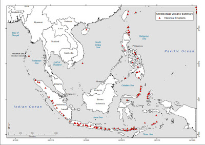
Map of Volcanoes of South  Asia


Volcanoes have loomed large in the history of humanity. Famous examples include: Thera on SantoriniPompeii: Eruption of Vesuvius and in Indonesia one of the most powerful in recorded history: Mount Tambora.

The aftermath of a volcano outburst often results in very fertile soil due to a combination of the minerals in the volcanic ash and stone spread across the area, and burnt organic matter. Of course this means these areas are very attractive for human settlements.

The people that live in these areas may develop a non-scientific understanding about the relationship between the volcano and the fertile soil nearby, and their culture and religion may be influenced by this understanding. They may frame volcanoes as one of the many manifestations of an often indifferent universe in which the gods and nature can alternately provide and take away. 

Can the gods or nature be appeased in any way? 

Or is the cycle of creation and destruction inevitable?

List of volcanoes in Indonesia

Saturday, July 20, 2019

How to start a Bronze Age: Metal Resources in Sundaland

It was the promise of gold that first brought the traders of my people to these lands. It was said that it was as common as the sand on the beaches and that even the people of the lowliest cast possessed golden artefacts to adorn their fingers, necks and ears. While that was an exaggeration, gold is still valued and prized amongst the wealthy and powerful, it is certainly more abundant here than anywhere else. 
The people of Sundaland are in want of tin, since the earth here does not yield much of it. Luckily that is something we can supply and the trade in one for the other is thus mutually beneficial. There are some tin mines in the central areas of this land but access and control of them are often contested and even the cause of wars. 
You might ask, why is tin deemed worthy of a trade for gold and something to shed blood for? Well it is necessary for the creation of bronze with which to fashion both the strongest plow and the sharpest spear.  
- An Account of Sundaland by Alom Takal 
Knowing how various natural resources are distributed in an area can give insight into how local economies developed and can provide a background for geo-political tensions. Just think about the importance of oil and other natural resources for what has happened over the past 100 years. In previous times it was much the same, however metals were what was sought after.

Access to better metals meant you could create better tools and weapons. It's not my intention to work out a detailed resource economy but to provide inspiration and ideas for why for example a certain city is located somewhere or why one city state wishes to attack the other. These are great hooks for stories and adventures.

Ancient people were aware of seven different metals: https://en.wikipedia.org/wiki/Metals_of_antiquity

Gold: https://en.wikipedia.org/wiki/Gold
Silver: https://en.wikipedia.org/wiki/Silver
Copper: https://en.wikipedia.org/wiki/Copper
Tin: https://en.wikipedia.org/wiki/Cassiterite
Lead: https://en.wikipedia.org/wiki/Lead
Iron: https://en.wikipedia.org/wiki/Iron
Mercury: https://en.wikipedia.org/wiki/Mercury

I imagine this setting as having a Bronze Age level of technology. While iron was known by ancient people it has a much higher melting point than the other metals and requires a more complicated procedure to forge and work with. Iron objects are very rare and usually produced by more advanced societies. Meteoric iron was also used, but again it requires advanced technology to forge.

Gold and silver are found natively meaning that once mined they are immediately ready to use. The others have to be processed first. Gold is relatively abundant in the area and stimulated traded with India and China in later times. Panning was a common according to this in depth article: Gold in early South East Asia. As far as I know Bronze Age societies didn't use currency but relied on trading goods or were run as so called Palace Economies (the central authority collected and redistributed resources as needed) but perhaps a relative abundance of gold could allow for the invention and use of currency. Edit: Recently I've read research that indicates currencies were indeed used in the Bronze Age although not always in the form of coins.

Bronze was very important since it allowed the creation of stronger tools and weapons. Bronze is an alloy consisting of roughy 88% copper and 12% tin. In fact some Bronze Age societies of the Eastern Mediterranean would trade batches of copper and tin ingots in a ratio of 9 to 1.

Copper is roughly 20 times as common as tin so the latter was the more valuable resource. The ancient Egyptians, Hittites etc. relied on tin from Afghanistan and some scholars liken it to oil in terms of its scarcity and importance to their civilisations. Wikipedia: Tin sources and trade in ancient times

In the map below I've labelled areas where metal ores are found using various public resources (I've included the highly valuable Jade as well as Obsidian). I've taken liberty to add in two extra sources of copper to ensure enough abundance for a Bronze Age similar to what occurred in the Eastern Mediterranean from roughly 3300 to 1200 BC. These are located in what is now South Vietnam and West Borneo.


The main tin deposits are in what is now Malaysia and central Sundaland (click to enlarge). Whomever has control of sources of tin controls who can create bronze in the entire subcontinent. There are tin deposits in what is now Burma and Northern Thailand but they won't be easily accessible as those areas are highlands and covered in dense forests, it might be that they haven't even yet been discovered. Perhaps, as told in stories of Alom Takal, there was trade of tin from what is now Afghanistan, through India and across the Bay of Bengal?

Remember that this map only shows a fraction of the river systems and that most of the landscape is covered in various types of forests and jungles. Natural resources might be abundant but that doesn't mean they are easy to access.


Friday, July 19, 2019

Sundaland Geographical Map

Here's my latest map of Sundaland (click it for a closeup view). As you can see I've opted for the inland sea and drawn only a couple of the main rivers because the area contains hundreds.

The overall geography might be a similar mixture as what you still see in South East Asia today (although the overall temperature was probably slightly cooler), forests and jungles but also grasslands and even an open savanna in the south. Also there are deep swamps in the centre of the subcontinent.

For the sources I used to create this map go here: Ecosystems of Sundaland


Monday, December 17, 2018

Sundaland Map - Work In Progress

I've been working on a map for the Sundaland region based on various maps I've found online. There seems to be quite a lot of information about where rivers where probably located and the type of vegetation that was likely present. I have no idea how accurate these are but I'm going to include them anyway.

Some of the maps show a landlocked sea to the east of the Thai peninsula and I'm wondering if I should include it in my map?


Here's one of my source maps without the inland sea.


And here's one with the inland sea. Which one do you think would be more interesting?


Here's Indonesia overlaid on top of maps of Europe and North America to give people an idea of the scale of the area. The inland sea would be the equivalent of one of the great lakes as far as I can tell.